


As time marches on, fewer people remember the ski resort that used to be in Rocky Mountain National Park.
Hidden Valley Ski Area, which closed in 1991 after operating for 36 years, gave Northern Colorado residents a ski destination that might only take 45 minutes to get to rather than the multi-hour drive required to reach the resorts along U.S. Interstate 70.
But challenges with a lack of snow on the ski runs, changes by park staff to focus on non-developed recreation opportunities, and overall management challenges that prevented competing with the larger Colorado resorts put the demise of Hidden Valley Ski Area into motion.
Located between Lower and Upper Hidden Valley along Trail Ridge Road, the resort had a ski lodge, ski school, a 500-car parking lot, ski lifts and rope tows. There was also a small ice-skating pond near the parking lot.
All of that was removed, however, when the resort closed, leaving just a large parking lot and a warming hut built with some materials from the original ski lodge.
The other aspect of the resort that remained were the ski runs that cut through the thick subalpine forest of Hidden Valley.
Although many of these trails are finally starting to see some regrowth of native vegetation 31 years after the resort closed, they do still provide paths through the forest for today’s backcountry skiers and snowshoers.
At only 1.1 miles from the warming hut at the west end of the parking lot to the upper reaches of the valley along Trail Ridge Road, snow-loving enthusiasts might eagerly set out on this trail for a quick adventure in the snowy woods. Don’t be fooled, however, because this trail climbs 1,066 feet in 1.1 miles, with some grades in excess of 40%.
For those willing to feel the burn of the uphill climb that goes straight up Hidden Valley, then start out at the parking lot, which is located 7 miles west of the Beaver Meadows Entrance along Trail Ridge Road.
Navigate around the west side of the warming hut and then follow the gulley straight up through the forest.
The trail gently rises from its start of 9,412 feet through a picnic area. Old ski runs can be seen to the left and the snow play area, the only place in the park where sleds — plastic only — are permitted, is directly ahead.
Continue up through the snow, following previous tracks as the trail is not marked. Downloading a map from an outdoor recreation app can help you navigate through the area, especially if falling snow fills in the fresh tracks.
About a half mile up the trail, the slope increases in steepness rising from about a 10% grade at this point to 45% in the next half mile.
But there is only 0.1 mile remaining of the trail from this point at the steepest grade so it’s best to keep pushing through the burning in the calf muscles.
The trail ends at Trail Ridge Road at 10,498 feet.
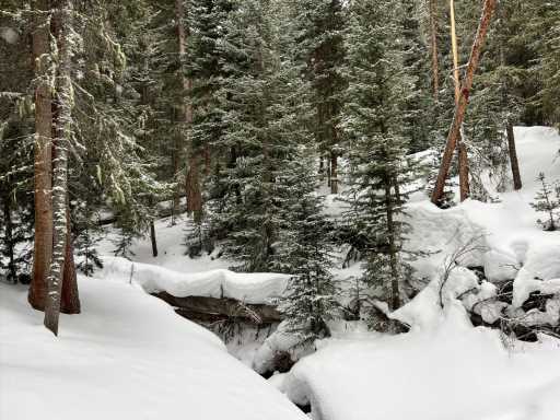
While hiking, stop to catch your breath and enjoy the views. Looking back out to the east offers views of the layers of thick lodgepole forest. Patches of the tundra peek through the forest when looking up the trail. Hidden Valley Creek gurgles below the snow, periodically revealing itself. And watching the surrounding forest for movement might garner views of pine squirrels, mountain chickadees and snowshoe hares.
To return to the trailhead, follow your route back down the valley. Steeper sections may require some careful navigation to prevent sliding down dramatic slopes.
Backcountry skiing is popular along this trail so keep an eye out for other trail users to prevent collisions, especially when navigating through thicker forest.
For more information about winter activities in Rocky Mountain National Park, including sledding, skiing and snowshoeing at Hidden valley, visit nps.gov.
Subscribe to our weekly newsletter, The Adventurist, to get outdoors news sent straight to your inbox.
Source: Read Full Article