


Many of Colorado’s trails wind through spectacular sites — hidden waterfalls, rocky peaks, dramatic ridge lines. But dotted along these Rocky Mountain paths is another scene that holds a different kind of emotion: plane crashes.
These sites are frozen in time, telling silent stories of violent wrecks that now, dozens of years later, are surrounded by hushed forests and relatively few human visitors. Soft, leafy plants have curled around the jagged and crumpled pieces of metal and saplings are slowly replacing the mature trees destroyed all those years ago.
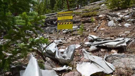
Hikers may see a remembrance sign with brief details at some of the wrecks, but the full stories remain mostly tucked away in the fading folds of history.
Trails where you can see plane crash sites include:
- Feb. 23, 1943: C-49J crash near Blodgett Peak
- July 19, 1943: B-24 bomber crash near Taylor Park in Gunnison County
- Oct. 18, 1943: B-17 crash at Pingree Park and Stormy Peaks
- June 13, 1944: B-17 crash near Crown Point and Flowers Road
- Jan. 21, 1948: C-47 on Navajo Peak near Ward
- Oct. 26, 1948: B-17 near Glenwood Springs
- April 3, 1952: L-19 crash near Palmer Lake
- Sept. 24, 1956: C-47 crash on Mount Yale in Chaffee County
- Oct. 12, 1957: T-33 crash in Cheyenne Mountain State Park
- June 27, 1965: T-33 crash off Bunce School Road
- Oct. 2, 1970: Wichita State crash near Loveland Pass
- Dec. 14, 1971: T-6 crash near Jasper Peak
Read the full story, including details from each crash and trail information, from our partner at thedenverchannel.com.
Subscribe to our weekly newsletter, The Adventurist, to get outdoors news sent straight to your inbox.
Source: Read Full Article