


Two distinctive mountains that tower over the prairie of southern Colorado have gone by many names.
To the Native Americans they were sacred and known as Wahatoya, meaning “breasts of the Earth.” To the Spanish they were Dos Hermanos, or “two brothers.” To white settlers they were an important landmark on the Santa Fe Trail, the easternmost peaks of the Rockies and a sign their long journey across the plains was nearing its end.
Today they’re known as the Spanish Peaks. Historical significance aside, this area is an outdoor lover’s playground, often lacking the crowds found at other mountain ranges across the state.
So this summer, instead of fighting weekend traffic on Interstate 70 or U.S. 285, why not take a drive south on I-25 to Walsenburg and explore one of Colorado’s lesser-known summer getaway spots? This is your guide to summer fun in Spanish Peaks Country.

Hiking the Spanish Peaks
West Spanish Peak is the taller of the two mountains, 13,631 feet versus East Spanish Peak at 12,688. But in summer you can drive much higher to the trailhead that will lead you to the west peak, making it the easier of the two to summit.
To get to West Spanish Peak, head west out of Walsenburg to Colorado 12, also known as the Highway of Legends (more on that later). You’ll notice numerous rocky dikes extending from the peaks, another feature that makes these mountains unique. The stony granite spines are remnants of the volcanic forces that built these peaks.
Pass through the quaint town of La Veta and turn left on County Road 46 (Cordova Pass Road). Built during the 1930s by the Civilian Conservation Corps to connect the towns of Aguilar and Cuchara, this road tops out at 11,260 feet. That’s where you’ll find the trailhead, across the way from the small Cordova Pass Campground (no reservations).
From there it’s a pleasant stroll until you reach timberline, where you’ll tackle a steep climb on a route marked by rock cairns to the summit. The hike covers 8 miles with 2,300 feet of elevation gain. Marvel at the dikes that extend like spokes on a wheel and the Sangre de Cristo Mountains, which form an imposing wall to the west. On a clear day you can look north and see Pikes Peak.
To reach the trailhead for East Spanish Peak from La Veta, take Cuchara Street. After the road turns to dirt, turn left at the sign for Huajatolla Valley. After 5 miles turn right at the sign for Wahatoya Trail 1304 and park. Those in four-wheel-drive vehicles can make it another 2 miles to the upper trailhead. Others can simply walk the road to the trailhead.
From the trailhead, follow a well-made, gentle trail 2 miles to the saddle between the two peaks (there are numerous backcountry campsites here). This is where the real fun begins as the trail – little more than a series of cairns – follows the saddle and then winds up through loose rocks to the summit. According to AllTrails.com there is a trail that follows a series of switchbacks for part of the route, but you’ll have to hunt for it. We didn’t see it.
Regardless, it’s nearly 11 miles and 4,000 feet up from the lower trailhead, which is why many hikers choose to make this trip an overnighter.
Both routes are in a designated wilderness area, so only foot and horse travel are permitted.

Camping around the Spanish Peaks
The Cordova Pass Campground is undeniably the prettiest camping in the area, but sleeping in the cold at 11,260 feet isn’t for everyone. I learned that the hard way many years ago after spending a frigid night there with my wife. After summiting West Spanish Peak we headed to the hamlet of Cuchara to buy a blanket that is still part of our camping gear box.
This was once a flourishing ski town, but lack of snowfall and financial difficulties forced the ski hill’s closure in 2001. There are still gift shops and several options for dining. Hit The Dog Bar and Grill for classic bar food and cold beer or the strangely named Cuchara Yacht Club for seafood and wine.
Not much goes on here in winter, though that could change if the decades-long effort to restart the ski area comes to fruition. (Backers say the lifts will turn during the 2023-24 snow season. Stay tuned.)
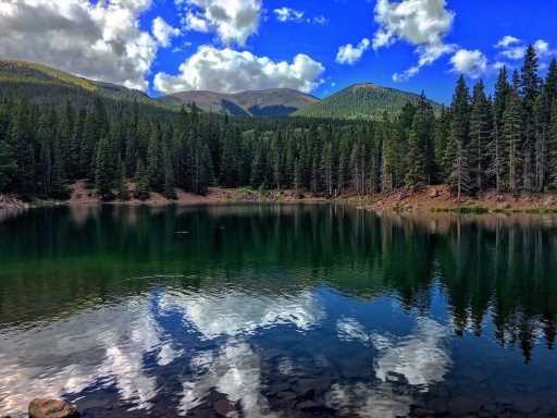
For more camping options, head south from Cuchara and right on Forest Service Road 422, a good dirt road, to the Blue Lake and Bear Lake campgrounds in the Sangre de Cristo Mountains. Both have sites reservable online at recreation.gov as well as first-come, first-served sites. There’s great lakeside fishing, as well as angling on Cuchara Creek. You’ll find several multi-use trails accessible from the campgrounds.
If you’re looking to camp somewhere on the way back to the Front Range, Lathrop State Park ($10 day pass per vehicle/$80 annual pass) near Walsenburg has a large campground and two lakes for boating and fishing. The lakes are warm enough for summer swimming, a rare thing in Colorado. You can also play a round of golf there. Make reservations online at cpwshop.com.

Scenic drives near the Spanish Peaks
The drive into Spanish Peaks Country is pretty enough, and the views on the aforementioned Cordova Pass are stunning. You can also take paved Colorado 12 to Cuchara Pass. This drive is known as the Highway of Legends National Scenic Byway. If you’re enjoying the pass you’ve already driven half of the byway, so why not drive the rest and stop for lunch in Trinidad?
Along the way you’ll pass Monument Lake Resort, a privately owned summer resort with camping, rental cabins and a lodge with a bar and restaurant. You can fish or rent a boat at the namesake lake. See details and plan your visit online at themonumentlakeresort.com.
Farther down the road you’ll pass Trinidad Lake State Park ($10 day pass per vehicle/$80 annual pass), which also offers camping and water activities in a mild climate. Make reservations online at cpwshop.com.
Finally you’ll reach Trinidad, a picturesque town with a rich history and a present economy tied to the arts. Drive into the heart of town and find a place to eat.
Hike a fourteener – Culebra
The rugged mountains west of the Spanish Peaks are known as the Culebra Range, named for 14,053-foot Culebra Peak. This mountain has the distinction of being the only privately owned fourteener in Colorado. Private ownership dates back to the 1840s when the Mexican government tried to encourage migration to the region by granting huge tracts of land to individuals.
Today it’s owned by the Cielo Vista Ranch, which allows hiking the mountain for $150 per person. Reservations are required. Visit cielo-vista-ranch.info for details.
Go off-roading in Spanish Peaks Country
The mountains in the Culebra Range offer many rough dirt roads to test your mettle and miles of multi-use trails popular among dirtbike and off-highway-vehicle enthusiasts. You can access two from the Cuchara Recreation Area, the area around the Blue Lake and Bear Lake campgrounds.
The Indian Creek Trail is recommended for beginner riders, while experts will enjoy the Trinchera Trail. Named for 13,517-foot Trinchera Peak, it takes you high into the rocks and tundra of that mountain, and even goes to a saddle near the top. You can check out the remaining equipment from a small mining operation near the saddle. A nearby hiking trail also leads to the summit and various camping sites on the mountainside.
Subscribe to our weekly newsletter, The Adventurist, to get outdoors news sent straight to your inbox.
Source: Read Full Article