


My feet crunch atop tiny pebbles as I move through the hillside of rolling sagebrush. The sunlight warms my hairline. Below me, the rich navy body of Blue Mesa glitters beneath a cirque of snow-capped desert peaks. A few minutes into my trail run, an imposing queue of 600-foot hoodoos comes into view, filling the horizon of the water’s northern shore.
I understand why this singletrack trail is named after the 30-million-year-old formation Dillon Pinnacles. The 4-mile route meanders into a small glen and up to a mesa beneath the volcanic rock. From the high point, I can see the San Juan Mountains, which poke above the mesa like shark fins piercing the surface of the sea. Having grown up in the region, I’m amazed by the amount of water below and how refreshing it is.
Curecanti National Recreation Area offers a unique opportunity for paddlers and boaters to find rejuvenation and solitude alongside bird watchers and hikers. The number of visitors here pales in comparison to the state’s more popular spots: 900,000 annual travelers venture through this giant recreation area compared to Rocky Mountain National Park’s 4.7 million.
Beyond hoodoos and glistening water, this 43,000-acre gem is chock-full of high-desert trails and deep ravines. In fact, the longest section of the Black Canyon resides in Curecanti: 19 miles, which is five miles more than the section of the gorge that’s designated as a national park. Visitors can explore historic exhibits, hike, fish, wind surf, sail, beach lounge and stay at hundreds of campsites, many of which can be reserved.
Here are a handful of ways to enjoy Curecanti:

Take a multiday paddle on Morrow Point Reservoir
At the Pine Creek trailhead, 29 miles west of Gunnison, park your rig and then hike your watercraft and overnight gear 1 mile down 232 stairs to the glassy Morrow Point Reservoir, which connects Blue Mesa Reservoir to Crystal Reservoir.
After the first .5-mile of swift current, the 11-mile stretch of water is calm and dwarfed by the magnificent, 1,800-foot-high walls of the Black Canyon.
The rock’s rough, chossy surface is a canvas full of charcoal, apricot and moss tones. Steeply angled shelves are clung to by Douglas fir, sagebrush and juniper trees. The only sounds you’re likely to hear are the rapid, twittering song of black swifts and the crashing water of Chipeta Falls.
Before you paddle westward, fill out a free, backcountry use permit at the trailhead. Choose one of the six campsites (Hermit’s Rest and Curecanti Creek have vault toilets) to arrange a water-side shelter on the sandy crescents. You’ll be surrounded by water but don’t forget to take a filter to remove viruses, bacteria, sediment and more from the water before consuming it.
Forewarning: The approach to this paddle trip is not for the faint of heart but the rewards are unforgettable.
Listen to the birds
From the woodlands to the sagebrush scrub and riparian zones, Curecanti offers habitat for a range of feathered creatures. Lined with cottonwoods, the Neversink trail holds a great blue heron rookery and is home to robins, red-winged black birds, woodpeckers, yellow warblers, and hummingbirds. Brown creepers and nuthatches peruse the bark for bugs. In winter, birders can spy bald eagles and American dippers, which dunk into the Gunnison River for treats.
Venture north of Morrowpoint Reservoir on Colorado 92 to peer off the Black Canyon’s zig-zagging rim. Keep your eyes open for speedy peregrine falcons, which dive up to 186 mph. Other birds that occupy the canyon include swifts, swallows, turkey vultures, black-billed magpies, red-tailed hawks and western bluebirds.
Blue Mesa Reservoir is home to three basins — Sapinero, Cebolla and Iola — that are landing grounds for great blue heron, western grebes and mergansers. Look along the banks for wading birds including sandpipers, phalaropes and gulls. And a migration of sandhill cranes moves through the area each winter and spring.
While hiking in the sagebrush, such as along Dillon Pinnacles trail, watch for the Gunnison sage-grouse, a native bird that is protected under the Endangered Species Act. To help support the sage grouse and other wildlife, keep four-legged friends leashed while exploring the area.
Visit the Cimarron Canyon Rail Exhibit
History buffs definitely need to stop at the Cimarron Canyon Rail Exhibit, a 10-year restoration effort on the west side of Curecanti and adjacent to Morrow Point Dam.
Turn off U.S. 50 into Cimarron, which started as a tent city during the construction of the Denver & Rio Grande Western Railroad. Soon, the cluster burgeoned into a town of 250 residents who supported the train industry.
Today’s outdoor exhibit includes an 1886 caboose, 1904 boxcar, a coal tender from 1935 and locomotive 278, the 1882 engine that ran on this railroad for close to 70 years. My favorite part of the display is the trestle, a 288-foot steel deck bridge that hangs over Cimarron Creek, surrounded by the towering canyon. Listed on the National Register of Historic Places, the trestle is the sole surviving structure of the ravine’s narrow gauge railroad. When the railroad line from Gunnison to Montrose was retired in 1949, the segment through the canyon, which included nine bridges, became a public road until Blue Mesa Dam was built in the 1960s.
After checking out the relics, take a hike on Mesa Creek trail. The 1.5-mile out-and-back route meanders along the north shore of Crystal Reservoir and features a picnic area. Campers can stay overnight at the first-come, first-served sites ($16/night), which rarely fill up, surrounded by giant cottonwoods.

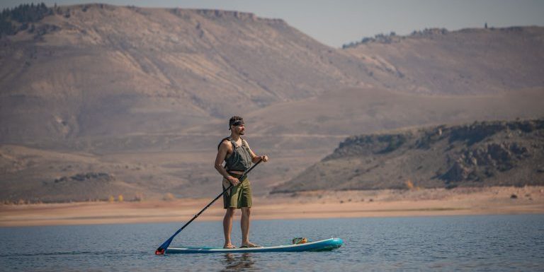
Camp at Elk Creek Campground and SUP Blue Mesa
At 7,540 feet, Elk Creek Campground offers bird’s-eye views of the rolling sagebrush-speckled slopes juxtaposed with the gleaming cobalt face of Blue Mesa, an idyllic perch to watch the sunset. You can walk to the water’s edge from your campsite. Or for a beach and SUP day, drive a few minutes to the Bay of Chickens or Dry Creek to picnic and paddle.
Beyond Elk Creek, another nine drive-up campgrounds decorate Curecanti (with a total of 385 sites, many can be reserved online). They offer electric hookups for RVs, flats for tents, and parking for pop-up trailers.
For boaters, Blue Mesa boasts 96 miles of shoreline with nine fee-free designated boat campsites with vault toilets and metal fire rings. Boaters also can disperse-camp along the southern and western shores or on Red Creek Island. Dispersed sites need to be established at least a half mile from any bridge, road, developed area and other backcountry campsite.
Given the transition of dispersed to designated camping around Crested Butte, which begins this summer, Curecanti offers great options for reservable camping during summer and early fall.

Go hiking (or backpacking) Inside the Black Canyon
There are seven established trails. Dillon Pinnacles is an ideal hike for spring and fall when the temperatures are cooler.
“Curecanti Creek is my favorite hike, which goes down into the Douglas firs and spruce, so you get shade,” said Matt Johnson, district interpreter and volunteer coordinator of Curecanti National Recreation Area.
The 4-mile hike delivers an elevation change of 900 feet. Explorers can extend their trip by backpacking, as there’s a single campsite, likewise dubbed Curecanti Creek, surrounded by steep cliffs at the trail’s end. Note: Backcountry use permits are free of charge, required and available at Pine Creek trailhead.
Johnson added, “You start off in the sun and go down next to Curecanti Creek, so you have the sound of water for much the way. It goes all the way down to Morrow Point Reservoir, right down to the water, and goes past waterfalls. John Wesley Powell said, ‘The Grand Canyon is a land of song. Mountains of music swell in the rivers.’ For me, that’s true. I like to hear that sound.”

Enjoy the Morrow Point Canyon Boat Tour
This leisurely out-and-back pontoon float takes visitors into the depths of the Black Canyon, past the resounding Chipeta Falls, and through the shadows of the Curecanti Needle. The awe-inspiring granite spire was the logo of the Denver & Rio Grande Western Railroad in 1882. Known as the Scenic Line of the World, the 15-mile segment of railroad precariously rolled passengers alongside the roaring Gunnison River near the bottom of the 2,000-foot, sheer gorge walls. Despite facing countless avalanches and rock falls, the operation withstood nearly seven decades offering scenic rides, hauling livestock and transporting ore.
The boat tour will dive into more railroad tales as well as stories of the canyon’s geology, wildlife, inhabitants and water management initiatives.
Visitors can park at the Pine Creek trailhead, 29 miles west of Gunnison, and descend 232 stairs to the water’s south side. Meander 1 mile on a smooth dirt path — which follows the ancient narrow gauge railroad bed — to the Pine Creek boat dock, where tourists climb aboard for the 90-minute ride.
Note: The tours are canceled for summer, due to the Pine Creek Dock renovation and U.S. 50 road construction, but typically operate from June to mid-September; $13-$25.
Subscribe to our weekly newsletter, The Adventurist, to get outdoors news sent straight to your inbox.
Source: Read Full Article