Editor’s note: This is part of The Know’s series, Staff Favorites. Each week, we offer our opinions on the best that Colorado has to offer for dining, shopping, entertainment, outdoor activities and more. (We’ll also let you in on some hidden gems).
Longs Peak has held a special place in my heart since the first time I climbed it 30 years ago. I love the way its sheer east face turns bright orange when it catches the rays of a rising sun. I love that it is visible from cities along the Front Range so I can see it often and, whenever I do, it awakens wonderful memories of the times I’ve been up there.
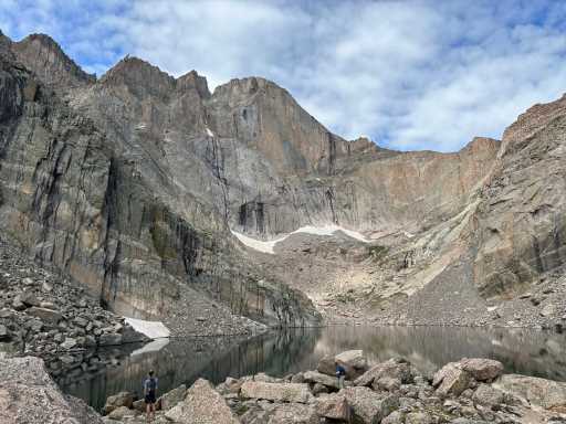
Nearly 2,500 feet below its 14,259-foot summit, at the foot of the east face, lies a beautiful alpine tarn called Chasm Lake. The summit of Longs towers over its western edge, and steep rock walls to the right and left soar 1,200 feet, making it one of the most spectacular alpine cirques in Colorado. It’s also one of the best hikes in Rocky Mountain National Park. No doubt for both reasons, Erik Stensland used it as the cover photo for his excellent guidebook, “Hiking Rocky Mountain National Park” (Rocky Trail Press).
A cirque is an “amphitheater-shaped basin with precipitous walls at the head of a glacial valley,” as defined by Britannica. Hiking to this one creates dazzling images in the mind that are sure to last a lifetime.
The lake is about 4.2 miles from the Longs Peak ranger station, with an altitude gain of 2,390 feet. The parking lot was already full when I arrived a couple of weekends ago at 6 a.m., as I suspected it would be, but I was able to park safely along the road about a half mile from the trailhead.
The hike begins at 9,400 feet, passing first through a lodgepole forest. About 2 miles up the trail, the path crosses a creek with waterfalls at Lightning Bridge, so named because there are signs warning of the dangers of lightning above the timberline, which hikers will reach less than a mile farther up.
Once reaching the timberline, the rest of the hike is mostly on rocky terrain, although there are many sections where rock steps are built into the path. Soon, the east face of Longs comes into view, massive and magnificent. At just over 3 miles, there is a trail junction at 11,533 feet where folks climbing Longs via the famous Keyhole Route take a right turn that heads up into the Boulderfield.
Hikers heading to Chasm Lake turn left and soon begin traversing a section of trail with a steep drop-off to the left. Below is a lovely alpine pond known as Peacock Pool, with waterfalls upstream from it.
Just before the lake, there is a short section of rock scrambling before the trail tops out and Chasm Lake can be seen. It is simply breathtaking to behold that 2,500-foot east face up close in all its grandeur. And the morning light illuminating the face is just right, or at least it should be, because this is one of those hikes where you want to be up and down — or most of the way down, at least — before afternoon thunderstorms fire up.
After the hike, I suggest a stop at the ranger station where there is a model of Longs Peak showing trails, mountain features and adjacent peaks, including 13,911-foot Mount Meeker which is connected to Longs. There are photos on the walls showing key sections of the Longs Peak climb and historical displays. On one wall hangs a Sunday Denver Post front-page story published in 2005 on Longs headlined “Ascent of Danger.” The story called Longs “one of the most challenging and prized of Colorado’s 54 peaks above 14,000 feet,” noting that “Longs is rivaled only by the Maroon Bells near Aspen as the deadliest mountain in Colorado.” And it is a strenuous climb, 15 miles roundtrip with a 5,000-foot elevation gain.
The Chasm Lake hike lacks the risks associated with climbing Longs, but it’s a wonderful way to see the great monarch of the Front Range up close.
Subscribe to our weekly newsletter, The Adventurist, to get outdoors news sent straight to your inbox.
Source: Read Full Article


