


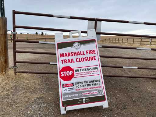
Open Space managers in Boulder County were forced to close a massive swath of popular recreational land adjacent to the path of the Marshall fire last month, and they are still evaluating a timeline for reopening the area.
The affected area is approximately 10 square miles of open space bounded by Marshall Road on the north, Colorado Highway 128 on the south, Colorado 93 on the west and McCaslin Boulevard on the east. With rolling hills, inviting trails and wide open vistas, the area is very popular for runners, mountain bikers and hikers. The eastern half is administered by Boulder County Open Space, while the western half is managed by City of Boulder Open Space and Mountain Parks (OSMP).
Investigators believe the origin of the costly fire on Dec. 30 was in a community near the intersection of Colorado 93 and Marshall Road. That’s very near the Marshall Mesa trailhead, which provides access to seven trails administered by Boulder OSMP. From there the fire moved east, driven by intense winds.

“Somewhere between 2,100 and 2,200 acres of property that OSMP has interests in were burned,” said John Potter, OSMP resource and stewardship manager, speaking at a recent public meeting. “We know that about seven miles of trails were in the burn area and are currently closed while staff does damage assessments and figures out a plan regarding the trailhead. We are still building an overall damage estimate, but it appears to be on the order of $1.5 million.”
There was less damage to land to the east managed by Boulder County Open Space, although trails and trailheads there also remain closed. Those trailheads on McCaslin Boulevard are very near areas of Superior that were devastated by the fire.
“We feel pretty confident that we’ll be able to open it by the end of February,” said Vivienne Jannatpour, public information manager for Boulder County Open Space. “We actually don’t have that much damage. We do have to do some trail clean-up from the wind, and there is a couple of trail crossings over drainages that they want to make sure are in good shape, because it protects the riparian area and gives people a path to walk through some wetter areas.
“The one area of significant damage that we did suffer is that we lost 15 miles of fencing. Basically, it’s an agricultural area that we put a trail through, so there’s grazing.”
The two open space entities have been sharing information and collaborating because their trails connect. It’s unclear whether they will reopen simultaneously. Jannatpour said Boulder OSMP isn’t ready to commit to reopening at the end of February.
“We all agreed that’s OK if we don’t have the same opening date, because they are looking at a lot more damage and a lot more recovery than we are,” Jannatpour said. “We agreed that the county would open even if the city is not ready, and the city will try to follow closely behind. They have some challenges that we don’t.”
Leslie Clark, director of parks, recreation and open space for the Town of Superior, said all of its parks, trails and playgrounds are closed.
“We have fencing that has been impacted, either burned or blown over,” Clark said. “We have playgrounds that have been completely or partially burned. We have some footbridges and some retention walls that have been damaged by the fire, and we have a lot of native grass and turfgrass that has been burned.”
To the north, Louisville open spaces haven’t been closed but town officials are encouraging people to stay out of burn areas for safety reasons. Davidson Mesa is one popular area under the management of Louisville Open Space.
“We haven’t made any official closures at this point,” said Emily Hogan, the city’s public information officer. “We are looking at it, and we’ll have more information in the next couple of days. We’re considering if we want to make official closures, and for how long.”
Subscribe to our weekly newsletter, The Adventurist, to get outdoors news sent straight to your inbox.
Source: Read Full Article